


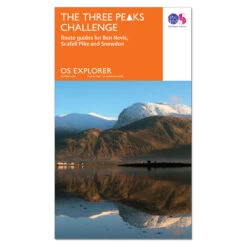

Leisure Map – The Three Peaks Challenge – Ben Nevis
Original price was: $12.99.$9.09Current price is: $9.09.
- Friendly, efficient service, always online.
- Quality You Can Trust
- Shop with Peace of Mind
- Peace of Mind with Every Purchase

Planning to do the Three Peaks challenge? Find a pre-planned route for each peak plus essential safety information.At 1:25,000 scale the OS Explorer Map is the Ordnance Survey’s most detailed folding map and is recommended for anyone enjoying outdoor activities.
DESCRIPTION
The Three Peaks Challenge is to climb the highest mountains of Scotland, England and Wales in 24 hours, including travelling. It’s a pretty tough challenge and is often attempted to raise funds for charity. If you are planning on taking it on, there is more information at the Official Three Peaks site. This map contains the mapping for ALL Three Peaks and includes: a safe and approved walking route for each peak, a quick guide to the history of each peak, hazard warnings, parking information.
ADDITIONAL INFORMATION
The essential map for outdoor activities, OS Explorer Maps are recommended for anyone enjoying outdoor activities including walking, horse riding and off-road cycling. Providing complete GB coverage, the OS Explorer map series details information essential in the great outdoors, including youth hostels, pubs and visitor information. Rights of way, fences, permissive paths and bridleways are clearly shown, ensuring you have the best information to get the most out of your time in the countryside.
Be the first to review “Leisure Map – The Three Peaks Challenge – Ben Nevis”
Related products


Hiking Gear
Hiking Gear
Hiking Gear

Hiking Gear
Hiking Gear
Reviews
There are no reviews yet.